The Risk Assessment Platform provides a mapping of a number of indicators at the community, sub-district and district levels within Idlib enclave to assist our partners in the humanitarian and development sectors in assessing risks that may affect their ability to implement projects, or hinder their efforts to realize planned outcomes, or achieve the desired impact within the community. The outputs of this platform are designed also to help to select the most appropriate locations for sustainable implementation. The first phase of this project provides information on 529 communities in Idlib enclave in northwestern Syria.
This platform is based on an in-depth analysis of a set of indicators developed by the OPC research team. Once these indicators were finalized and assigned a numerical value, the OPC data management team designed the equations and algorithms to measure them in order to determine the risk and need levels in each community and build the beta version of the platform. Then the OPC field researchers in Idlib collected the required data at the community level, which then were analyzed by the data management team who proceeded to test the platform and refine its algorithms over several technical stages to reach the highest possible levels of accuracy. The platform is updated periodically as our field team surveys security incidents and military movements in Idlib enclave on a daily basis, as well as monitoring changes at the community level that may affect population numbers and movement, or the composition or/and affiliation of the local council.
To provide community-level results to measure the risk to project implementation in 529 communities in Idlib enclave by studying a number of indicators that, within the current situation in northwestern Syria and the standards adopted by international organizations, may jeopardize the ability of partners working on humanitarian and development programs to implement their projects and/or reach the planned outcomes. These indicators would also help the partners to develop their projects within Idlib enclave for the time being, in line with the military and field developments, in order to protect their staff within Idlib enclave and to ensure the best possible results and reach as many beneficiaries as possible.
This platform is one of the OPC projects that combines the technical and practical expertise of both the research and data management teams to develop tools to monitor and measure a number of factors that affect the work of local and international organizations and the implementation of service delivery, development and humanitarian projects in Syria. The aim of these projects is to provide up-to-date, meticulous and fact-based data for partners in order to help them set and prioritize their programs and projects based on the analysis of data drawn from a rigorous monitoring and mapping of relevant factors on the ground. Thus, more features would be added to the platform in the near future to measure more important factors such as access, impact and other aspects related to the service and development sectors and the reconstruction process.
Such features could include specific indicators to respond to the needs of implementers to track a variety of operational risk in regard to access and safety to help them safeguard the integrity and continuity of the implementation process and the safety of their personnel inside Syria. Such indicators could include:
In addition to the indicators included in the current Platform that covers incidents on the community level, military developments and military control, further indicators could be tracked in relation to the stability of communities, safety of personnel and feasibility of implementation such as:
The platform is based on a mapping and monitoring of 529 communities in Idlib enclave to measure risk and need ratio by identifying military control, security and military situation, and local council affiliation. A mathematical relationship has been created between these indicators so that the combination of these indicators provides a preliminary result of the level of risk in each society. The 52 indicators used to anticipate military and political developments in Idlib platform are then factored in with the other risk indicators to give the final risk result. The number of residents and IDPs in each community and the number of humanitarian and service organizations active in those communities were analyzed to give a preliminary assessment of the need level of each society which along with the risk level would enable the platform to provide recommendations on humanitarian priorities in Idlib enclave as well as risk assessment.
This includes information on the military control in each of the 529 communities and the relationship between the different military factions in each area. Currently, Idlib enclave is controlled by two main forces; the National Liberation Front (NLF), which is composed of a number of Syrian factions supported by Turkey, and Hay’at Tahrir al-Sham (HTS), which is classified as a terrorist organization. The risk is assessed based on the presence and/or control (partial or complete) of HTS in each community.
The National Liberation Front is composed of the following factions:
The field team conducted a mapping of all the local councils in the 529 communities in Idlib enclave, their affiliations and their relationship with the military factions in the region, that in addition to the extent of the council's association with the security, service delivery and administrative entities affiliated with the armed factions, in particular the institutions associated with HTS and the Salvation Government.
The field team monitors, on daily basis, all the security and military incidents in Idlib enclave, which may have an impact on humanitarian work and the implementation of projects in the area.
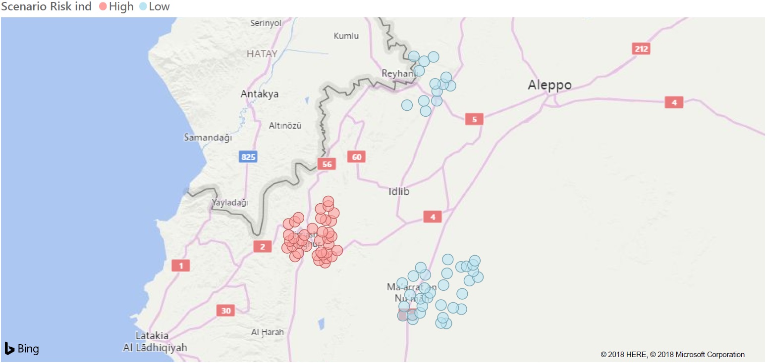
In order to properly factor in the changing military situation in and around the Idlib enclave, the research team is utilizing the information provided by Idlib Platform through which they are monitoring military and political developments in the enclave. The platform provides ongoing monitoring and analysis of 52 indicators that feed into the 5 probable military and political scenarios for the future of the enclave. Those indicators include the political and military talks between Turkey, Russia and Iran and any agreements that might emanate from these discussions, mobilization and operations and military attacks around and inside Idlib enclave, changes in local governance and alignments of local military and civil actors. After measuring the risk indicators, the military and political indicators are factored in by dividing the 529 surveyed communities into sectors that correspond to the military and political scenarios outlines in Idlib platform, where a mathematical relationship was also created between the result of the risk indicators and the results of the scenario ratios to reach a final conclusion. The outcome is one of the following results: Low Risk - Medium Risk – High Risk – Sever Risk.
In order to assist partners in defining and prioritizing their service delivery and humanitarian priorities, the needs assessment index was developed based on:
It should be noted here that this indicator is not sufficient to properly asses the needs in any of the 529 communities in terms of service and humanitarian projects as it does not include a multisectoral needs assessment or an assessment of the reach and effectiveness of projects implemented or to be implemented in the area. Rather, the indicator is designed to give a preliminary estimate of the need level in the community. To provide more detailed and accurate needs assessment in the community /sub-district /district. The OPC is ready to provide multi-sectoral needs assessment services according to the needs and interests of partners and add the result as additional indicators to the platform or in separate reports and studies per request. If partners already have information or results of needs assessment studies, the data could be added to the platform and factored in with the other indicators and outcomes, and the result could be shared with the partner (data owner), other relevant partners, or/and publicly based as requested.
By integrating the final risk index with the need indicator, the 529 communities will be classified into six levels so that partners have a list of communities ordered according to the implementation prospects and sustainability according to international guidelines and humanitarian principles and standards.
The risk matrix depends on measuring four factors:
Each of the factors listed is assigned a value between 0 and 1, where 1 is the worst and indicates a higher risk, and 0 indicates a low risk. The factors values is then aggregated to measure the final risk ratio in the area as follows:
The numerical value of each factor and its weight are calculated through combining the information provided by the research and data teams. The weights and initial contribution value were imposed based on the opinion of the research team and the estimation of the data team. The results were then tested by experimenting with real values corresponding to data from the ground in several communities. Then the weights and values were modified to provide an accurate reflection of events and realties on the ground.
Finally, humanitarian, development and service delivery work is directed by balancing the safety of project implementers and commitment to international humanitarian standards, with the levels of humanitarian work in each region by combining the results of the risk index with those of the need index. As a result, the studied areas are divided into two categories:
Where the descending order of optimal locations for humanitarian and development implementation is as follows:
The risk is illustrated in the following table

It should be noted that all the values of weights and contributions are not necessarily fixed but can be modified according to the examination and analysis of the research team.
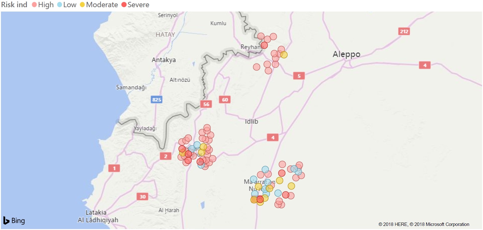
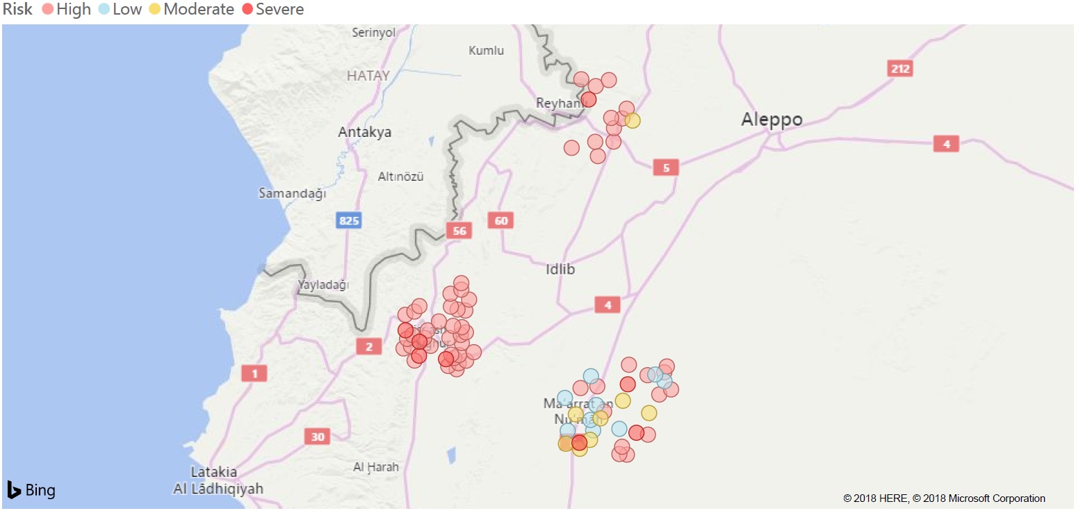
The results will be presented at the community level through interactive maps (currently we show static maps).
Here are examples of three-tier initial results for three sub-districts we have chosen (Jisr Al-Shughour, Ma'rat Al-Nu'man, and Al-Dana).